
 Pencarian
 Merek
Merek Online Chatt
 JNE Tracking
  Latest News
 Produk Promo


 Spesial Produk
-38x38.jpg)


Garmin Oregon 650
 Klik untuk memperbesar |
Tidak ada gambar tambahan untuk produk ini.
|
| Tweet |
More Features, More Satellite Power Behind a Tough, Bright Touchscreen
- 3" sunlight-readable touchscreen display with dual orientation
- 8 MP autofocus camera with LED flash/torch
- Worldwide basemap with shaded relief
- 3-axis compass with accelerometer and barometric altimeter sensors
- Dual battery system — 2 AA batteries or included rechargeable internal NiMH pack
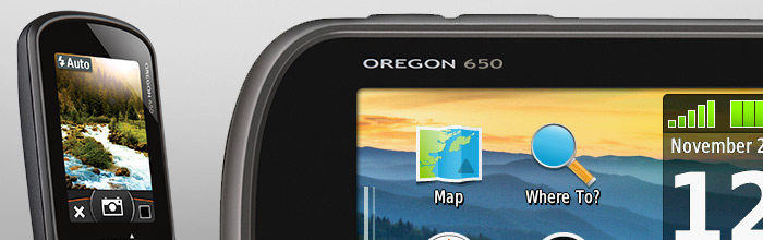
With high-sensitivity GPS and GLONASS satellite tracking, worldwide basemap with shaded relief and customizable buttons for 1-touch image capture and waypoint marking, Oregon 650 opens a new world of GPS mapping and positioning.
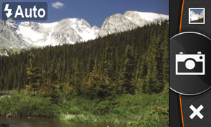
Quality Photos
Take quality photos with Oregon 650's built-in 8 MP autofocus digital camera. Each photo is geotagged, allowing you to navigate back to that exact spot. Share the photos with all your friends through Garmin Adventures. For more storage, insert a microSD™ card; you can even view pictures from other devices on microSD card with Oregon's picture viewer.
Touch and Go
Oregon 650 has reflective display technology for the most brilliant, sunlight readable touchscreen we’ve ever made. It's as vivid in full bright sunlight as it is in shade. The screen has been strengthened for impact resistance but still accommodates gloved operation. And with dual-orientation, multi-touch screen, you won’t just look at maps, you’ll interact with them when you zoom in, pan out and rotate the display.
Double Your Power
Oregon 650 features our state-of-the-art dual battery system. You’ll have the option of using the internally rechargeable NiMH pack (included) or traditional AA batteries — NiMH pack charges when the device is connected to external power.
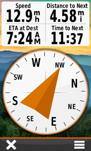
Get Your Bearings
Oregon 650 has a built-in 3-axis electronic compass with accelerometer tilt compensation to show where you're heading even when standing still, or not holding it level. Its barometric altimeter tracks changes in pressure to pinpoint your precise altitude. You can even use it to plot barometric pressure over time to keep an eye on changing weather conditions.
With its high-sensitivity, WAAS- and GLONASS-enabled GPS receiver and HotFix® satellite prediction, Oregon 650 locates your position quickly and precisely, and maintains its GPS location even in heavy cover and deep canyons.
Share Wirelessly
With Oregon 650 you can share your waypoints, tracks, routes and geocaches up to 50 times faster with other wireless compatible Garmin handheld devices. Plus, you can share large files too like photos, Garmin Adventures and Custom Maps. Just touch “send” to transfer your information.
Add Maps
Adding more maps to Oregon is easy. Load TOPO U.S. 24K maps and hit the trail; add Trailhead Series TOPO maps and explore famous treks like the Appalachian Trail and the Pacific Crest Trail; plug in BlueChart® g2 preloaded cards for a great day on the water; or load City Navigator® map data for turn-by-turn routing on roads. Add satellite images to your maps with BirdsEye Satellite Imagery (subscription required).
Load All the Geocaches
No more picking, choosing and planning, just download them all. The Oregon 650 can hold up to 4 million. Download every cache on OpenCaching.com. Load caches using your favorite program or website that supports GGZ files. All your paperless geocaching features will be there for every cache. Read full descriptions, hints and logs. View cache photos. Filter caches by size, terrain, difficulty and type. Connect to chirp-enabled caches. Record your logs in the field. Do it all.
Plan Your Next Trip
Take charge of your next adventure with BaseCamp™, software that lets you view and organize maps, waypoints, routes and tracks. This free trip-planning software even allows you to create Garmin Adventures that you can share with friends, family or fellow explorers. BaseCamp displays topographic map data in 2-D or 3-D on your computer screen, including contour lines and elevation profiles. It also can transfer an unlimited amount of satellite images to your device when paired with a BirdsEye Satellite Imagery subscription.
![]()
![]()
![]()
![]()
![]()
![]()
SPECIFICATIONS :
Physical & Performance: |
|
| Unit dimensions, WxHxD | 2.4" x 4.5" x 1.3" (6.1 x 11.4 x 3.3 cm) |
| Display size, WxH | 1.5"W x 2.5"H (3.8 x 6.3 cm); 3" diag (7.6 cm) |
| Display resolution, WxH | 240 x 400 pixels |
| Display type | transflective color TFT touchscreen |
| Weight | 7.4 oz (209.8 g) with batteries |
| Battery | rechargeable NiMH pack (included) or 2 AA batteries (not included); NiMH or Lithium recommended |
| Battery life | 16 hours |
| Waterproof | Yes (IPX7) |
| Floats | No |
| High-sensitivity receiver | Yes |
| Interface | high-speed USB and NMEA 0183 compatible |
Maps & Memory: |
|
| Basemap | Yes |
| Preloaded maps | no |
| Ability to add maps | Yes |
| Built-in memory | 3.5 GB |
| Accepts data cards | microSD™ card (not included) |
| Waypoints/favorites/locations | 4000 |
| Routes | 200 |
| Track log | 10,000 points, 200 saved tracks |
Features & Benefits: |
|
| Automatic routing (turn by turn routing on roads) | Yes (with optional mapping for detailed roads) |
| Electronic compass | Yes (tilt-compensated 3-axis) |
| Touchscreen | Yes |
| Barometric altimeter | Yes |
| Camera | yes (8 megapixel with autofocus; digital zoom) |
| Geocaching-friendly | Yes (Paperless) |
| Custom maps compatible | Yes |
| Photo navigation (navigate to geotagged photos) | Yes |
| Hunt/fish calendar | Yes |
| Sun and moon information | Yes |
| Tide tables | Yes (with optional Bluechart) |
| Area calculation | Yes |
| Custom POIs (ability to add additional points of interest) | Yes |
| Unit-to-unit transfer (shares data wirelessly with similar units) | Yes (plus images and custom maps) |
| Picture viewer | Yes |
| Garmin Connect™ compatible (online community where you analyze, categorize and share data) | Yes |
 GARMIN ETREX 30 Dapatkan Potongan Harga 021-5842278 Rp 0 |
 GARMIN GPSMAP 64 Dapatkan Potongan Harga 021-5842278 Rp 0 |
 GARMIN GPSMAP 62S Dapatkan Potongan Harga 021-5842278 Rp 0 |
 GARMIN GPSMAP 78S Dapatkan Potongan Harga 021-5842278 Rp 0 |
 MOBILEMAPPER 10 ASTECH GPS Rp 24.000.000 |
 TRIMBLE JUNO SB Dapatkan Potongan Harga 021-5842278 Rp 0 |
 TRIMBLE JUNO SC Dapatkan Potongan Harga 021-5842278 Rp 0 |
 TRIMBLE JUNO SD Dapatkan Potongan Harga 021-5842278 Rp 0 |
 TRIMBLE JUNO 3D Dapatkan Potongan Harga 021-5842278 Rp 19.500.000 |
 MOBILE MAPPER 100 ASTECH GPS Rp 45.800.000 |
 GARMIN MONTANA 650 Dapatkan Potongan Harga 021-5842278 Rp 0 |
 Garmin GPSMAP 620 Dapatkan Potongan Harga 021-5842278 Rp 0 |
 Garmin GPSMAP 62SC Dapatkan Potongan Harga 021-5842278 Rp 0 |
 Trimble Juno 3B Dapatkan Potongan Harga 021-5842278 Rp 17.500.000 |
 Garmin Monterra Dapatkan Potongan Harga 021-5842278 Rp 0 |